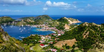
Story and photos by Lexi Fisher and Chris Doyle
Carriacou sits at the southern end of the chain of islands known as the Grenadines, which it is geographically part of. Politically, it belongs to Grenada as part of the tri-island nation of Grenada, Carriacou, and Petite Martinique. Most of it is anyway; the border with St. Vincent & the Grenadines runs along the latitude that slices across Carriacou’s northern tip at Gun Point, leaving the last hundred yards in another country. No one seems too bothered.


“This is an island with over a hundred rum shops and only one gasoline station.” Frances Kay, This — is Carriacou.
Truth be told, there are now two gas stations and a few less rum shops after Carriacou was hit hard by Category 4 Hurricane Beryl in early 2024, but it is as enchanting as ever. Kayaks (people from Carriacou) are resourceful and were quick to start the rebuilding and rehabilitation process. Many businesses, especially those within the yachting industry, were fully operational by December 2024.
Besides the yachting industry, residents continue to live by farming, fishing, and seafaring, and are among the friendliest in the Caribbean. Just about every part of Carriacou is of interest, but Windward, the traditional center of boatbuilding, should definitely be part of your tour, as should the road running from Windward to the north end of the island. Windward was made famous by the documentary Vanishing Sail, and it is here that you can see the fishing fleet arrive under sail. If you cannot afford a taxi, take a bus over to Windward and hike. Closer to town, a destination with a great view is the hospital, which sits high on the hill overlooking Hillsborough Bay.
Carriacou has lovely anchorages, pleasant hiking, marinas, yacht services, a dive shop, and entertaining bars, restaurants, and cafes.
The island has no natural source of water besides rainwater, which is often in short supply, especially in the dry season. Please be respectful and conserve water when you can.
Carriacou is a Kalinago word meaning “island surrounded by reefs,” but do not worry: the approach down the west coast is simple enough. When sailing from the north it is safest to pass to the west of Jack a Dan, but if you take the trickier route east of Jack a Dan, watch out for the reef, about 5 feet deep, roughly one-third of the way between Craigston Point and Jack a Dan. Favor the Jack a Dan side of the channel (but not too close). You can then pass on either side of Sandy Island, Mabouya, and Sisters to get around Point Cistern and into Tyrrel Bay.
There is usually a flashing green light on Jack a Dan and a flashing red light on the buoy east of Sandy Island.
Two anchorages north of Hillsborough are worth a thought: Anse La Roche and Sparrow Bay, though both are untenable in northerly swells. When coming from Hillsborough, pass outside Jack a Dan. Hillsborough is a good anchorage except in bad northerly swells, when you will be better off in Tyrrel Bay.
Tyrrel Bay is huge, well-protected, and very popular with cruisers. It is the commercial port of Carriacou and has two marinas.
A sizeable, navigable mangrove lagoon lies on the north side of Tyrrel Bay. It is fun to row up in here to explore (you can motor to the entrance). Upon entering, you encounter a new and very peaceful world, often seeing herons, iguanas, and jumping fish. Bug repellent is advised. It is all part of the Sandy Island Oyster Bed Marine Protected Area (SIOBMPA) and is one of the few good hurricane holes in the Grenadines, though even the best ones aren’t safe from a direct hit, as Hurricane Beryl demonstrated in 2024.
The mangrove lagoon should only be used by yachts when a hurricane threatens. The depth in the first bay is about 8 feet, and when a storm is forecast it fills up quickly. Yachts with less than a five-foot draft can get over the bar at the turn and go way up inside, where there is a lot of room. The mangrove oysters are protected, so do not collect or buy them if offered.
Out in the bay, businesses line the waterfront and a road separates them from the sea. The shore was once thickly wooded with manchineel and seagrape trees, but most were cut down to increase the visibility between the boats and the businesses. When Hurricane Lenny threw record-breaking swells into the bay in 1999, it devastated the unprotected shoreline and destroyed much of the road, turning several properties into beachfront real estate. The government then built the big seawall that now lines the waterfront.
Doyle Guides contain the Eastern Caribbean’s most comprehensive and reliable sailing information, available in hard copy and online through a free mobile app, website, and Facebook group. (www.doyleguides.com).

Grenada/Carriacou Entry and Exit Procedures from Noonsite
Ports of Entry
There is one port of entry in Carriacou at Carriacou Marine in Tyrrel Bay and two in Grenada, one at Port Louis Marina in St George’s and the other at Prickly Bay Marina in Prickly Bay.
Advance Paperwork
All visiting yachts should pre-register with SailClear prior to arrival.
For visitors from many countries a visa is not required. Stays of 90 days are typically granted and can be extended.
Entry Process
On arrival, the captain should proceed to the customs and immigration offices, on site at the marina, with the SailClear notification ID number, crew passports and boat paperwork. A cruising permit will be issued during check-in.
Exit Process
Same as the entry process. Vessels will settle up any outstanding cruising permit fees and need to depart within 24 hours.
Rates
For a double handed yacht less than 50 feet, it is approximately $50 (US) to cruise Grenada for 30 days or less. See Noonsite Grenada Fees for full details. Clearance outside normal working hours will incur overtime fees. (www.noonsite.com/place/grenada/view/fees/)
Check Noonsite for more detailed information and updates. This information is provided by Noonsite.com, specialists in worldwide formalities for yachts, and was accurate press time.