ADVERTISEMENT
Caribbean Compass
  • Home
  • Cruising
  • Destinations
    • Anguilla
    • Antigua & Barbuda
      • Barbuda
    • Bahamas
    • Barbados
    • British Virgin Islands
      • Anagada
      • Jost Van Dyke
      • Norman Island
      • Virgin Gorda
    • Colombia
      • Santa Marta
    • Dominica
    • Dominican Republic
    • Grenada
      • Carriacou
    • Puerto Rico
    • St. Barts
    • St. Lucia
    • Sint Maarten & St. Martin
    • St. Vincent & Grenadines
      • Bequia
      • Canouan
      • Mayreau
      • Union Island
    • Trinidad & Tobago
    • U.S. Virgin Islands
      • St. John
      • St. Thomas
      • St. Croix
    • All Other Islands
      • Guadeloupe
      • Martinique
      • Montserrat
      • Nevis
      • Panama
      • St. Kitts
  • Events Calendar
  • Regattas & Rallies
    Antigua Defends Nations Cup Title for Seventh Year as Caribbean Dinghy Championship Marks 30th Edition in Sint Maarten

    Antigua Defends Nations Cup Title for Seventh Year as Caribbean Dinghy Championship Marks 30th Edition in Sint Maarten

    Anegada:  Cow Bones, Shipwrecks & Lobster at Sunset

    The New CSA Majors Trophy – A Grand Finale

    Team TTO Competes in Sint Maarten at the 2026 Caribbean Dinghy Championships

    Team TTO Competes in Sint Maarten at the 2026 Caribbean Dinghy Championships

    Anegada:  Cow Bones, Shipwrecks & Lobster at Sunset

    Registration Opens for the West Indies Regatta Festival 2027

    2026 Caribbean Dinghy Championship Returns to Sint Maarten for 30th Edition

    2026 Caribbean Dinghy Championship Returns to Sint Maarten for 30th Edition

    St. Vincent and the Grenadines Sends Largest-Ever Team to Caribbean Dinghy Championships

    St. Vincent and the Grenadines Sends Largest-Ever Team to Caribbean Dinghy Championships

    Anegada:  Cow Bones, Shipwrecks & Lobster at Sunset

    Salty Dawg Departures Scheduled from Florida, Bermuda

    2026 ARC and ARC+ Fleets Gather in Gran Canaria for Atlantic Crossings to the Caribbean

    2026 ARC and ARC+ Fleets Gather in Gran Canaria for Atlantic Crossings to the Caribbean

    2026 St. Barth Cata Cup Draws 42 Teams for 18th Edition

    2026 St. Barth Cata Cup Draws 42 Teams for 18th Edition

  • JOIN NEWSLETTER!
No Result
View All Result
  • Home
  • Cruising
  • Destinations
    • Anguilla
    • Antigua & Barbuda
      • Barbuda
    • Bahamas
    • Barbados
    • British Virgin Islands
      • Anagada
      • Jost Van Dyke
      • Norman Island
      • Virgin Gorda
    • Colombia
      • Santa Marta
    • Dominica
    • Dominican Republic
    • Grenada
      • Carriacou
    • Puerto Rico
    • St. Barts
    • St. Lucia
    • Sint Maarten & St. Martin
    • St. Vincent & Grenadines
      • Bequia
      • Canouan
      • Mayreau
      • Union Island
    • Trinidad & Tobago
    • U.S. Virgin Islands
      • St. John
      • St. Thomas
      • St. Croix
    • All Other Islands
      • Guadeloupe
      • Martinique
      • Montserrat
      • Nevis
      • Panama
      • St. Kitts
  • Events Calendar
  • Regattas & Rallies
    Antigua Defends Nations Cup Title for Seventh Year as Caribbean Dinghy Championship Marks 30th Edition in Sint Maarten

    Antigua Defends Nations Cup Title for Seventh Year as Caribbean Dinghy Championship Marks 30th Edition in Sint Maarten

    Anegada:  Cow Bones, Shipwrecks & Lobster at Sunset

    The New CSA Majors Trophy – A Grand Finale

    Team TTO Competes in Sint Maarten at the 2026 Caribbean Dinghy Championships

    Team TTO Competes in Sint Maarten at the 2026 Caribbean Dinghy Championships

    Anegada:  Cow Bones, Shipwrecks & Lobster at Sunset

    Registration Opens for the West Indies Regatta Festival 2027

    2026 Caribbean Dinghy Championship Returns to Sint Maarten for 30th Edition

    2026 Caribbean Dinghy Championship Returns to Sint Maarten for 30th Edition

    St. Vincent and the Grenadines Sends Largest-Ever Team to Caribbean Dinghy Championships

    St. Vincent and the Grenadines Sends Largest-Ever Team to Caribbean Dinghy Championships

    Anegada:  Cow Bones, Shipwrecks & Lobster at Sunset

    Salty Dawg Departures Scheduled from Florida, Bermuda

    2026 ARC and ARC+ Fleets Gather in Gran Canaria for Atlantic Crossings to the Caribbean

    2026 ARC and ARC+ Fleets Gather in Gran Canaria for Atlantic Crossings to the Caribbean

    2026 St. Barth Cata Cup Draws 42 Teams for 18th Edition

    2026 St. Barth Cata Cup Draws 42 Teams for 18th Edition

  • JOIN NEWSLETTER!
No Result
View All Result
Caribbean Compass
No Result
View All Result
Home Island Spotlight
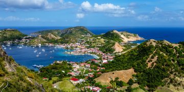
Colorful image of Guadeloupe Terre de Haut bay and town with buildings along the coastline. Small ships anchored in port. Cruise destination. Green mountains in the background.

Colorful image of Guadeloupe Terre de Haut bay and town with buildings along the coastline. Small ships anchored in port. Cruise destination. Green mountains in the background.

Guadeloupe – Island Spotlight

Caribbean Compass by Caribbean Compass
August 5, 2025
in Island Spotlight
Reading Time: 6 mins read
A A

Story and photos by Lexi Fisher & Chris Doyle  

Within the Southern Leewards, north of the verdant, precipitous hills of Dominica and south of the historic harbors of Antigua, is Guadeloupe, known by the Caribs as Karukera (Island of Pretty Waters). The island has a population of about 375,000 and is part of France. Marie Galante and Les Saintes are offshore islands that are also part of the country but are far enough away to feel like an adventure and are not covered in this spotlight. 

Guadeloupe is partly agricultural, with an emphasis on sugar cane, and the local rhum is highly valued in France. Tourism is also important and it is a popular destination for French nationals. Guadeloupe is composed of two islands in the shape of a lopsided butterfly, with a narrow mangrove channel separating them. Whoever named the islands had a sense of humor, because the larger mountainous one is called “Basse-Terre” (low land) and the smaller, low one “Grande-Terre” (large land). Grand-Terre is a much older island. It once looked more like Basse-Terre, but over millions of years its mountains have eroded. Basse-Terre is a younger volcanic island. Boats of up to 1.8 meters draft and 12 feet mast height can fit under the bridges and navigate between the two islands on the Rivière Salée.   

Cloud forest vegetation

Most cruisers will love visiting the interior, at least in mountainous Basse-Terre, which has some exceptional views and sites. Route de la Traversée runs through the national park, smack in the middle of Basse-Terre. The Crayfish Waterfalls are well worth a visit and swim but make your way to the upper part to encounter fewer tourists. If you are driving yourself, take the detour to Morne à Louis for the spectacular view from the top, overlooking Pigeon Island. Some buses that run between Pointe à Pitre and Pointe Noire take Route de la Traversée.   

The most dramatic destination is the 350-foot Carbet Waterfalls in the south of Basse-Terre. If you rent a car, it is easy to find the car park and reach the second falls by a beautiful 30-minute walk on a trail through the rainforest. But this is just the beginning, as many good hiking trails have been built in this area. Try the one-hour hike up to the first falls. This takes you above the rainforest and into cloud forest. These first falls, which are as tall as the second falls, are red from the volcano. Whichever falls you hike to, remember to take your bathing things: they all have good bathing pools, though hiking is sometimes restricted due to landslides. 

Other attractions in this area are several crater lakes, including Étang As de Pique, shaped like an ace of spades. By contrast, Grand-Terre has a pleasant countryside of rolling hills, especially the northern part, with lots of sugar cane and picturesque, ruined windmills. Pointe à Pitre, the largest city, has a big marina, excellent chandleries, and you can get all kinds of boat work done here.  

Most French post offices have ATMs, and these are sometimes easier to find than a bank. I had no problem getting cash from my debit card but it frequently failed in restaurants, many of which seem to exclusively use cards that require a PIN.  

General Navigation  

In addition to the IALA-B buoyage system, yellow buoys are used in the French territories to mark many different things. I have seen them used for no anchoring areas, fishing limits, an area where sand is being dredged, underwater pipelines, waterskiing runs, and as navigation buoys. If the buoys are in deep water, there is usually no problem navigating through them. If they are placed near a beach or resort area, it is unwise to anchor inside them. Yellow and black buoys are always navigation buoys on the IALA-B system. 

Fort Delgrès Memorial, on the slopes of a volcano in Basse-Terre, commemorates the leader of an anti-slavery uprising.

Guadeloupe’s Northern Coast 

Guadeloupe’s northern coast has a massive sheltered area called Grand Cul-de-sac Marin that is protected by an outer reef that extends up to four miles from Rivière Salée. If sailing outside the reef, be aware that shallow water (three to seven feet) extends a mile and a half west of the obvious outer reef and breaks in most seas. To avoid this, it is best to stay outside the red and white channel buoy that marks the entrance to the small commercial port of Ste. Rose. This is at approximately 16°23.5’ N, 061° 44.3’ W. 

You can pass inside Îlets a Kahouanne and Tête à l’Anglais, though the water is only 12 to 14 feet deep, so it is best avoided in large swells or rough conditions. Watch out for shoals close to shore as you turn down the west coast. 

Western Coast  

Guadeloupe’s western coast is mountainous enough that winds on the lee side can be light and fluky, and there may be a wind acceleration effect at the ends of the island, particularly the north end.  

From Deshaies south to Pointe Du Vieux Fort, the coast is steep-to, but a quarter of a mile offshore clears all dangers. You can pass either side of Pigeon Island, which lies halfway up the coast. A shoal called La Perle lies about a quarter of a mile offshore, two bays north of Deshaies. In heavy surges it breaks dramatically. There is another shoal off the hotel to its north.   

Watch out for fish farms as these come and go. Four anchorages are spaced along the leeward coast. In calm weather you can tuck in almost anywhere else that appeals to you.     

Doyle Guides contain the Eastern Caribbean’s most comprehensive and reliable sailing information, available in hard copy and online through a free mobile app, website, and Facebook group. (www.doyleguides.com). 

Doyle Guide chart of Guadeloupe

Guadeloupe Entry and Exit Procedures 

Advance Paperwork: 

Customs and Immigration clearance in the French Antilles can be completed online. This Noonsite French Antilles Clearance Guide explains the process. https://www.noonsite.com/report/french-antilles-clearance-for-yachts/ 

For visitors from many countries, a visa is not required. 

Entry Process: 

Yachts that complete online clearance are free to explore Guadeloupe, with no further steps required. For yachts unable to complete formalities online, in person clearance remains available at customs computers in approved establishments at the ports of entry. 

Ports of Entry (POE): 

There are six ports of entry for Guadeloupe: Basse Terre, Deshaies, Les Saintes, Marie Galante, Pointe-a-Pitre and Saint Francois. See Guadeloupe main ports for more details on the ports of entry. https://www.noonsite.com/place/guadeloupe/- mainports 

Exit Process: 

The same options as entry apply. Yachts requiring a departure stamp should plan to visit an approved clearance point for endorsement. Departments of France (St. Martin, St. Barts, Guadeloupe, and Martinique) all require yachts to clear out of one, before sailing to another. 

Rates: 

There are no customs and immigration fees. There is a small admin fee (3-5 Euros) for use of clearance point computers. 


Check https://www.noonsite.com/place/guadeloupe/view/clearance/ for more detailed information and updates. This information is provided by Noonsite.com, specialists in worldwide formalities for yachts, and was accurate at press time.  
Tags: Guadeloupe
Previous Post

Stories From the Sea: Trust, Preparation, and Offshore Sailing 

Next Post

August 2025 – Caribbean Compass

Recommended For You

Anegada:  Cow Bones, Shipwrecks & Lobster at Sunset

by Caribbean Compass
November 2, 2026
0
Anegada:  Cow Bones, Shipwrecks & Lobster at Sunset

Story and photography by Simon Scott & Bonnie Harrison The British Virgin Islands are ideally situated in the turquoise waters of the Caribbean Sea. There are four larger...

Read moreDetails

Island Spotlight: The Saintes

by Caribbean Compass
September 26, 2026
0
French West Indies Charter: Culture + Sailing

Story and Photos by Lexi Fisher and Chris Doyle The Saintes are some of our favorite islands in the Eastern Caribbean. They have a distinct identity shaped by...

Read moreDetails

Island Spotlight: Mustique

by Caribbean Compass
September 15, 2026
0
Island Spotlight: Mustique

By Lexi Fisher and Chris Doyle Mustique, like St. Barths, is a Caribbean island rife with celebrity lore. It was developed by socialite Colin Tennant, who bought the...

Read moreDetails

A LOOK BACK: Anse à La Barque, Guadeloupe, and the Struggle for the West Indies

by Caribbean Compass
August 3, 2026
0
A LOOK BACK: Anse à La Barque, Guadeloupe, and the Struggle for the West Indies

Story and photos by Paul Weston Anse à la Barque is a small bay on the western coast of Guadeloupe, about twelve miles north of the Island’s southern...

Read moreDetails

Island Spotlight: Barbuda

by Caribbean Compass
August 3, 2026
0
Island Spotlight: Barbuda

Story and photos by Lexi Fisher and Chris Doyle Barbuda, part of the dual-island nation of Antigua and Barbuda, lies about 22 nautical miles north of its sister...

Read moreDetails
Next Post
August 2025 – Caribbean Compass

August 2025 - Caribbean Compass

How to Advertise in Caribbean Compass

Compass Marketing Services

How To Submit an Article

About Us

Issue Archive

Newsletter Archive

Where to Find Compass in Print

Article Archive

Privacy Policy

Categories

  • Airlines
  • Beach Bars
  • Beaches
  • Book Reviews
  • Business
  • Carnivals
  • Cruising
  • Destinations
  • Diving
  • Eco News
  • Events
  • Geography
  • History
  • Hotels
  • Hurricanes
  • Island Spotlight
  • Magazine
  • Marinas & Boatyards
  • Navigation
  • News
  • On Shore
  • Reader's Forum
  • Recipes
  • Regattas & Rallies
  • Resorts
  • Restaurants
  • Rum
  • Sea Life
  • Tributes
  • Uncategorized
  • Weather
  • Wildlife
  • Yacht Charter
  • Yacht Services
Join Our Newsletter

Caribbean Marine Weather Resources

Caribbean Events Calendar

Reader's Forum

Center of Effort - Letter from the Editor

RECENT POSTS

  • Immigration And Maritime Services, Temporarily Relocated To Ferry Dock At Pjia During Simpson Bay Dock Refurbishment  November 1, 2026
  • Guadeloupe Announces Anchoring Restriction at Carénage November 1, 2026
  • Trapped Carriacou Boats Launched November 1, 2026
  • Caribbean Compass – November 2026 October 27, 2026
  • Antigua Defends Nations Cup Title for Seventh Year as Caribbean Dinghy Championship Marks 30th Edition in Sint Maarten October 26, 2026

© 2026 Caribbean Compass

No Result
View All Result
  • Home
  • Cruising
  • Destinations
    • Anguilla
    • Antigua & Barbuda
      • Barbuda
    • Bahamas
    • Barbados
    • British Virgin Islands
      • Anagada
      • Jost Van Dyke
      • Norman Island
      • Virgin Gorda
    • Colombia
      • Santa Marta
    • Dominica
    • Dominican Republic
    • Grenada
      • Carriacou
    • Puerto Rico
    • St. Barts
    • St. Lucia
    • Sint Maarten & St. Martin
    • St. Vincent & Grenadines
      • Bequia
      • Canouan
      • Mayreau
      • Union Island
    • Trinidad & Tobago
    • U.S. Virgin Islands
      • St. John
      • St. Thomas
      • St. Croix
    • All Other Islands
      • Guadeloupe
      • Martinique
      • Montserrat
      • Nevis
      • Panama
      • St. Kitts
  • Events Calendar
  • Regattas & Rallies
  • JOIN NEWSLETTER!

© 2026 Caribbean Compass